
Mior
Excursion map
Skånebilder
Ancient monuments
Southwest Skåne
Karaby hills
Photo album
Slideshow
Pictures:
20 April 2020
From road
At a distance
Pass through
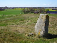
Erected stone
View from stone
Pasqueflower 1
Towards church
Southwest
West
Pasqueflower 2
Pasqueflower 3
To peak
View west at peak
View south at peak
Burial mound
Pine grove
Meadow Saxifrage
Yellow
Pasqueflower 4
Peak from stone
Peak from depression
In depression
Pasqueflower 5
Pasqueflower 6
Pasqueflower 7
Pasqueflower 8
Slope with Pasqueflower
Parking at church
From church
The visitors
27 May 2010
Parcing
Road
Hills
Passage
Up
Stone
Towars peak
South west
East
South
Cows
North
Meadow Saxifrage
South east
Read more>>
Naturguiden
Skånetrafiken
 Karaby hills
north of the Västra Karaby church just west of Kävlinge, is an ancient monument in a double sense. Created by glacial ice-rivers in ancient times, and one buried on them the dead during the Bronze Age.
April 20, 2020:
Park by the church in Västra Karaby.
A sign says that the car park is also for those who are going to visit
Karaby hills. Walk the gravel road towards the slopes.
An angle walk leads out onto the slopes.
It is pasture apart from the fenced-in burial mounds.
Today, horses graze in a paddock by the farm, not on the slopes.
A stone is erected on one of the burial mounds.
Goes into the next pasture via a passage. Fairly sandy ground.
A few pasqueflower on the slope with the highest burial mound.
Goes up to the top. Nice views. A pine grove in the north.
In the south a depression and beyond, fields and the church.
A few single Meadow Saxifrage. Goes to the erected stone for coffee.
Then to the depression below the top. Many rabbit holes in the slopes.
On one slope lots of pasqueflowers. Beautifully. Goes back to church.
Meets the caretaker who opens the church for us.
My company was confirmed in the Church quite a few years ago.
A company with dogs is on its way to the top of the slopes.
We're driving home.
27 May 2010: Karaby hills (Karaby backar), north of the Västra Karaby church just west of Kävlinge, is an ancient monument in a double sense. Created by glacial ice-rivers in ancient times, and one buried on them the dead during the Bronze Age. I park at the church. From there I walk a few hundred meters on a narrow dirt road. Before me lies the hills surrounded by flat farmland. Arrive at a passage to the hills, and one (as is often the case) bleached unreadable information plate. In order to protect the mounds from the grazing cows are the heaps fenced, passages do so that you can get in to them. On a burial mound is a raised stone. I continue up to the highest point, a barrow at the top of the hills. From here there are views out over the plains, where Scania lit yellow of rape fields. Looking at the horizon one see the familiar silhouettes of Turning Torso, Oresund Bridge, the contemporary ancient memory Barsebäck nuclear power plant, Lund Hospital. To the north is a pine grove. Leave my views to go to a small mound. In the hollow between them is a meadow with blossoming Meadow Saxifrage. There is no passage in the fence surrounding the mound, but you can unhook the fence. From the mound, I look north, out over rape fields. The downward sun begins to look out from behind the clouds. I lie in the grass on a slope and enjoy the evening.
Map
GPS: WGS84 decimal (lat, lon) 55.81082, 13.036931
