Mior
Excursion map
Skånebilder
Central Skåne
Osarps mölla
Photo album
Slideshow
Pictures:
16 April 2021
Parking
Past houses
Gravel road
Along road
Iron ring
From road
Up on it
On the aqueduct
South side
East
Towards mill
Expansion
Towards road
From expansion
Embankment
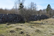
Stone wall
North
Detail
Stones
Along south
Wet in south
From north
From south
Wet in north
Pasqueflower
After stile
Pasture
Fence
Read more>>
Naturguiden
Skånetrafiken
 Osarps mölla
near Munkarp west of Höör. An aqueduct supplied a mill with water. The water was led from a pond to the mill. The mill and the 300 meter long gutter were completed in 1895. The mill was used until 1924.
April 16, 2021
Park in the parking lot to Munkarp's pasture.
There are already some cars there.
Today, it is not the pasture that attracts.
We're going to Osarp's mill. I'm not sure if it's possible to park at the mill.
It's not that far to go from here.
Continues to walk on the gravel road we came on.
Passes some houses, following them to the left on a major gravel
road through forest.
Soon we come to what is left of the mill, the remains of an aqueduct,
out on a pasture.
The aqueduct provided a mill with water.
The water was led from a pond further up to the mill.
The mill and the 300 meter long gutter, of which
the last part is an aqueduct, were completed in 1895.
The fall height was six meters. The mill was used until 1924,
when the stream dried up and the customers became fewer.
The house was demolished the following year.
The gutter, which is built of solid boulders,
has withstood the test of time. It is wet on both sides of the aqueduct.
Goes up on the aqueduct. It ends at some kind of expansion,
lower stone foundations, and then becomes an earth wall.
First try to go back on the south side, but too wet.
Goes therefore on the north side, also wet there but you can jump between
the tufts. On a boulder is an iron ring, where the carriage horses were tied.
We go back on the gravel road to the parking lot.
Want to see if you can walk over Munkarp's pasture to the mill.
Begins to follow the path, turns off up the slope to a plateau at
the stone fence to the pasture to the east. Pasqueflower blooms on the slope.
Walks across the pasture to the houses just before the mill.
Here you have to crawl under a fence to get out of the pasture,
it is possible but we do not. Goes back across the field.
Map
GPS: WGS84 decimal (lat, lon) 55.946749, 13.478523
